.png?1784117450)
LOT SIZE 302.000 acres
MLS#VAKQ2000202
STATUSACTIVE
PROPERTY TYPELand - Farm
SCHOOLKING AND QUEEN COUNTY PUBLIC SCHOOLS
Property Description
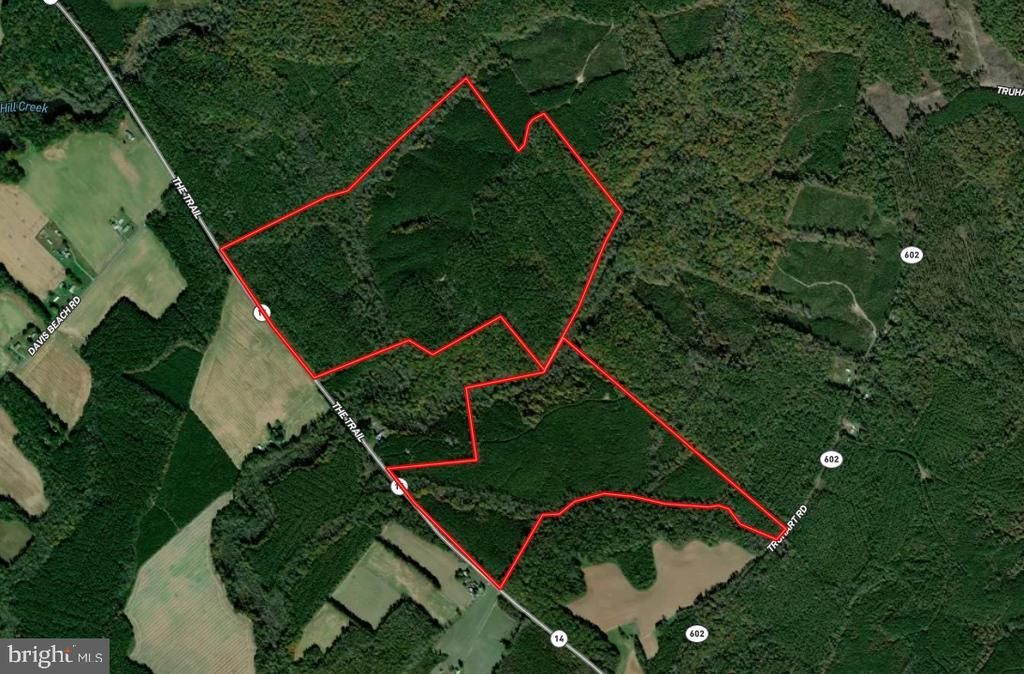
Sally White Tract (BK2142) — Key Land & Tax Summary The Sally White Tract is approximately 302 acres, positioned along a defined access point off The Trail, providing direct and reliable entry into a contiguous block of conserved forestland within the Dragon Run watershed. This established frontage enhances usability and operational access, while the tract itself remains embedded within a broader network of protected timberland and wetland systems . Protected under a conservation easement held by The Nature Conservancy, the property is permanently maintained as a working forest—preserving its ecological integrity while supporting sustainable timber management. The tract is defined by its scale and continuity, contributing to one of the largest unfragmented forest systems in the lower Chesapeake Bay region. Its timber base supports ongoing forest management practices, while its position within the Dragon Run and Mattaponi River corridor reinforces both habitat value and long-term environmental significance. As part of this broader conservation landscape, the property benefits from structural protections that prioritize land continuity and ecological function. Per paragraph 2.1 Subdivision and paragraph 2.2 Building Envelopes, these properties can be managed for limited residential use, designed to minimize impact on the surrounding forest. The tract’s size and internal access also support a range of recreational uses, including hunting and passive land enjoyment, without compromising its primary function as managed timberland. The Sally White Tract is best understood as a scaled, institutionally aligned landholding—where conservation objectives and biological productivity converge within a protected and increasingly scarce forest system. Property boundaries are estimated based on available data and are not warranted. Property owner to provide title research for Buyer prior to closing. Location & Identity Name: Sally White Tract Legal Description: Sally White #2142 and Sally White #2 #6680 Parcel ID: 24-31L-961 and 24-31L-944 County: King and Queen County, VA Coordinates: 39.0457549, -76.6412712 Acreage & Size Total Acres: 302 acres (note: marketed 302 acres—needs reconciliation) Volume Breakdown Hardwoods Sawtimber: 436.57 MBF Pulpwood: 2,586.36 tons Softwoods Sawtimber: 1,727.20 MBF Pulpwood: 10,390.82 tons Assessment and Taxes Assessed Value (2025): $672,100 Land Value: $672,100 (no improvement value) Tax Amount: $3,494.92 annually
Property Features
Property Type: Land - Farm
Lot Size: 302.00 Acres
Taxes: $3,494
Feature Descriptions
Days on Site: 91
Lot Dimensions: 302.00 Acre(S)
Sewer: Not Applied for Permit
Water: None
Local Schools
School District: KING AND QUEEN COUNTY PUBLIC SCHOOLS
Listed By / Shown By
Listed By
Agency Name: The Land Group
Agency Phone: 4109343478
Shown By
Agent Name: Treva Thomas
Agent Phone: (804) 334-4735
Agency Title: Joyner Fine Properties
Estimate Your Payment
Estimated Payment
$ 3,478.70 per month $3,013.70 Principal & Interest $291.17 Property Tax $173.83 Homeowner's InsuranceChange Payment Information
©Joyner Fine Properties - Seller will consider paying buyer agent compensation based upon the terms and conditions of any offer made. Said compensation to be negotiated in the purchase agreement.
Privacy Policy / DMCA Notice / ADA Accessibility
This site is hosted, designed and copyright
© 1994 - 2026 by
Delta Media Group, Inc. -- Patent Pending --
Agency License Information: Joyner Fine Properties and its agents are licensed in the Commonwealth of Virginia.
Agent License Information: Licensed in the Commonwealth of Virginia
The Trail | MLS# VAKQ2000202
This land located at The Trail, King and Queen Court House, VA 23085 is currently listed for sale with an asking price of $596,000. The property has approximately 302.00 Acres. The Trail is located within the KING AND QUEEN COUNTY PUBLIC SCHOOLS school district. Search King And Queen Court House real estate on www.trevathomasrealestate.com today.